U-LIMS
• Web GIS based Land Acquisition and Apenation
• pnked Documentaion of Notifications, Compensation and Disputes redressal.
• Corporate Social Rehabiptation
• Repository of Gazzete Notifications, 3(1), 6(1) Intimations and Notifications

GIS Based Land Management Information (LMIS) System
The prominent aim in automation is overcoming the barriers to delivering effective services created by bureaucracy and departmentalization. Government’s major objective is to streamline governance and services so as to become more user-friendly and responsive to citizens' needs; and the costs of complying with government bureaucracy are to be substantially reduced. Municipal Governance is to be automated in three ways - First services and agencies are to be linked up horizontally; clear demarcation of functional areas between departments to be established; public services are to become more holistic; and agencies are to be encouraged to collaborate more actively in confronting social and terrorism related problems. Secondly, government is to be 'joined-up' vertically to the general public who uses the services. Public services are to be made more convenient to use, by means of such automated electronic facilities for lodging forms and direct telephone service lines, many of which will be available round the clock. And thirdly, policy makers will be 'joined-up' more effectively to operational managers, so that the strategic levels of government become more sensitive to the practical issues involved in delivering quality and effectiveness.
- The automation allows the display of all information on the screen, along with the graphics, maps and other integrated features like current state of administration, the available resources and planning. The integrated information at one place allows optimum resource allocation and mobilization.
- Automation will allow the application of modern technologies like GIS, Remote Sensing and GPS for carrying out cost effective, accurate, data collection, integration, analysis, planning, management and maintenance. The updation of the information will be regularized and the dynamic planning and decision making will be promoted.
- The sharing of technology and information between the different departments will become easier and more efficient and repetition of the activities will be avoided saving resources and time of the government machinery, it will go a long way in gearing up the current bureaucratic system of decision making.
- The transparency in the governance will increase as the public access to the information will be enabled and the monitoring of the corrupt procedures will be possible enhancing reliability of the information.
GIS is still one level above this enabling layer of technologies, as it acts as a “Decision Support System” by providing analytical capabilities through simple and yet powerful visualization. In this context, the inherent capabilities of the technology offered in a GIS are looked upon as one having a great potential to successfully cater to the specified requirements.
The primary objectives of the GIS integrated works management system were
- Initiate a GIS centric business solution, which addresses the basic needs various departments in a Municipal corporation.
- Develop a workflow system, which enables the user to locate the status of each task.
A decision support system for the higher authorities
Providing services to the growing population is becoming increasingly difficult. mGIS provides crucial planning input for infrastructure planning, land use planning, Water Distribution and planning, town development and planning. mGIS assist and eligible for central assistance under the sub-mission Urban Infrastructure and Governance
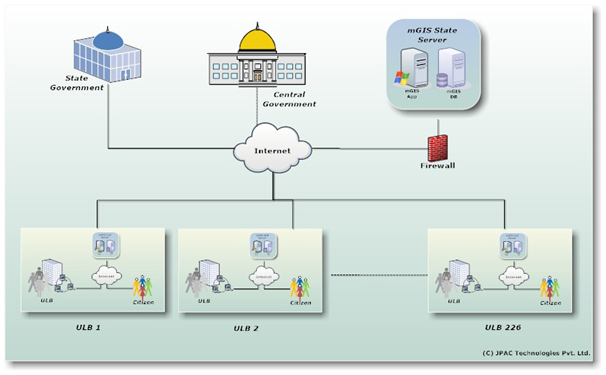
The following are broad objectives.
- Better appreciation of the land base and the land management processes through visual representation.
- Facilitate GIS based monitoring of Land Acquisition/ Alienation processed Resettlement & Rehabilitation activities, Corporate Social Responsibilities activities.
- GIS based Decision Support (DSS) tool (query/ analysis) to assist the management in decision making process.
- Remote, secured web dissemination of map based land information.
- Support to the project engineering/ management team, utility service team through provision of appropriate land information.
Conduct a detailed System Requirement study to facilitate analysis of the involved processes, availability of input data, identification of resource requirement (data, infrastructure, personnel and cost) at operational, management and strategic levels, identification of gap areas and to develop a detailed System Requirement Specification document.
Development of Design Specifications covering Application Design, Database Design, Coding Specification, Application/ Database testing Specifications for the LMIS.
Development of GIS based integrated Land Management Information System.
Implementation & Commissioning of Land Management System.
Conduct training programs for system users/ decision makers/ system administrators.
System Operationalization & Handholding for a mutually agreed period
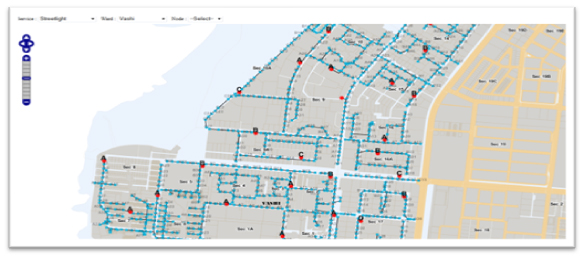
The Users
Functionaries in the Land Section are the primary users of the Land Management Information System. Besides, the system shall also be used by the IT Section, Resettlement & Rehabilitation (R&R) section, Corporate Social Rehabilitation (CSR) section and Utility Services departments. A brief description of the primary interest of different functional sections is as follows.
- To monitor the land acquisition/ alienation processes, identify the gap areas, implement remedial measures.
- To assist the project engineering team in coordinating the Land Acquisition plan with the project engineering plan.
- Following-up in the Govt. to accelerate the Land Acquisition/ Alienation processes.
- Tracking of Award Compensation/ Payment for the private land.
- Keeping Record of Financial transactions.
- Use the above as a Estate Information System in future.
- Support in management of Land Information database
- Generation of Decision Support/ Strategic Information requirements
Tracking of compensation in lieu of land as per the R&R policy of Govt. / Relocation of the displaced families in the R&R colony. Planning and Implementation of CSR activities in the Project affected/periphery villages.
Keeping track of the Activities/ Beneficiaries /Financials.
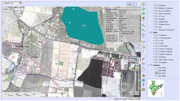
Land Acquisition/ Alienation Process
The process of land acquisition/ alienation is initiated with filing of land acquisition application with the state nodal agency for allotment of land to the Industries. On receipt of the application the agency verifies the application along with the documents and requests for the administrative approval from the concerned administrative department. The private land documents are scrutinized, approved by IDCO and are sent to the concerned district Land Acquisition Officer (LAO) for initiation of land acquisition process. The Govt. land documents are scrutinized, approved and sent to the concerned office of the Tehsildar for initiation of alienation process.
The Govt. land is classified into different land classes based on their recorded land type mentioned in the Record of Right (RoR). The Govt. land is usually categorized into the land classes such as Leasable, Gochar, Communal, Forest and Departmental. The land alienation is executed by the office of the concerned tehsildar through a number procedural step for each land classes based on statuary requirements. The private land is acquired through the land acquisition process executed by the office of the concerned district Collector. Private land acquisition process involved a number of important procedural milestones and involves higher public interactions.
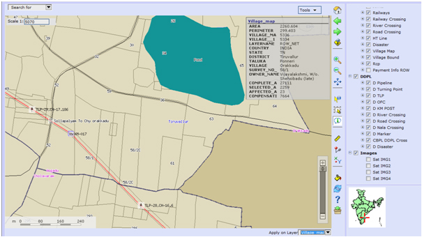
System Overview
The Land Management Information System shall be installed at the Server facilities available at Information Technology Section located at the Common Site Office building. The Land department shall be able to access the system through high band-width internet connectivity. The central server based Land Management Information System shall be accessible through Intranet based on the Local Area Network (LAN) facility available. The major components of the system setup are as follows.
Application Features
The Land Management System is a Web enabled system with the following application features.
Client Server Architecture: Separation of the server-side components from the client side components resulting in efficient code execution and implement application load balancing. Multitier application shall enhance execution efficiency and code maintenance.
User Interface: The user interface shall be ergonomically designed with menu driven application component access, selection of appropriate color, controls, application messages, context sensitive help to facilitate easy application access and long hours of operation.
Application Security: The application shall be embedded with multiple security layers with appropriate security logic to restrict unauthorized access to the system components.
Standard Geo-database: Implementation of standardized Geo database definition shall facilitate data compatibility and interoperability.
Documentation: The application shall be provided with a help document system to provide assistance on operation of the application software Scalability: The application shall be developed on standard system architecture and application design to facilitate future up gradation and feature expansion.
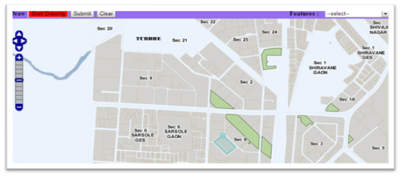
Functional Components
The Land Management System shall be developed as an integrated application with multiple functional components loosely coupled with a common data repository. The functional components are governed by the application security rules and are accessible by the users with appropriate combination of application and object level privileges. A brief description of the core functionalities of the different application components is described as follows.Components
- Land Acquisition/ Alienation Monitoring Component
- Resettlement & Rehabilitation Monitoring Component
Land Acquisition/ Alienation Monitoring Application Component
Feature Highlights
- Secured Component accessibility through user-id and password
- Privilege based availability of component features
- Standard user interface with common controls for menu and database
- Customized user interface for map based application components
- Client side data validation routines for data input interfaces
- Map manoeuvring controls (Zoom in/out, Extent, Pan etc.)
- Map Controls (Table of Content, Map View, Map Layout)
- Query builder for generation of query datasets
- Map/ Chart/ Text based preformatted reports
- Query based user defined maps/ reports
- Map tools (Distance/proximity measurement, Information window, feature selection)
- Report on Land Schedule/ land class wise maps
- Summarization of land class wise area for alienation/ acquisition ( maps/reports/ charts)
- Progress of Land alienation/ acquisition at project/ village levels (maps/ reports/charts)
- Identification of project/ villages wise process gap areas (maps/ reports)
- Print generation of land alienation/ acquisition process documents
- Project/ Village/ Plant utility level Projected completion of land alienation/acquisition processes. (report/ chart)
- Land alienation/ acquisition process time overrun (report/ chart)
- Project/ villages/ plant utility wise plot linked compensation payment status (maps/reports)
- Project/ villages/ plant utility wise plot linked compensation possession status (maps/reports)
- Land process based Financial Reports.
- Village wise no. of Project Affected/Project Displaced families (map/ report)
- Village wise report on socio-economic parameters of Project Affected/ Displaced families (map/report))
- Distribution of beneficiary type (R&R policy 2006)
- Progress of work in R&R colony (map)
- Payment of compensation to the PAF/ PDFs (map/ report)
- Status of eviction of project displaced families (map/ report)
- Relocation details of PAF/ PDFs (report)
- Rehabilitation details (occupation, training, income) details of the PAF/ PDFs.
The Land Management Information System shall maintain voluminous/ comprehensive data related to the land base, land acquisition/ alienation processes, Implementation of R&R activities, implementation of corporate social responsibilities. A preliminary study was conducted to evaluate the data need for development of the information system.
After acceptance/ approval of detailed System Requirement Specification, the development of the Land Management System shall include the following.- System Design Specification document
- Land Management System – Compiled Application
- Land management System - Application
- User’s Manual
- System Manual
- Installation GIS Server Software
- Installation of the GIS Editing Software
- Installation of the Database Server Software
- Configuration of Web Server
- Installation of land Management System
- Installation/configuration of geo-database
- Installation of Application
- Application testing/tuning

Request a Callback

